Researchers using high-resolution satellite imagery and a geospatial algorithm to identify rapid and abrupt landscape change in the Arctic find additional indicators of ground collapse due to warming climate
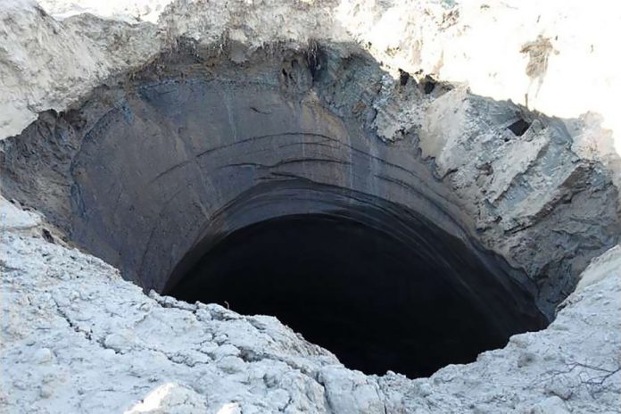
In 2014, workers on the Yamal Peninsula in western Siberia noticed a deep, mysterious crater within the permafrost that had seemingly exploded like a volcano. The discovery of the feature, now known as a gas emissions crater (GEC), energized international news coverage, as well as a flurry of scientific research to understand the phenomenon. Now, a new study by scientists at Woodwell Climate Research Center and colleagues, captures GECs in formation and reveals the magnitude of landscape change across the Yamal and Gydan Peninsulas using high-resolution satellite imagery and a novel geospatial algorithm.
The latest science suggests that GECs form when subterranean methane accumulates beneath ice-rich permafrost, which can over-pressurize, deform the land-surface, and explode catastrophically. This activity is associated with warmer air temperatures, so as the climate warms and temperatures rise in western Siberia, that may in turn accelerate GEC formation in the region, increasing greenhouse gas emissions and posing a risk to humans and infrastructure. Understanding these risks however, has been hindered by limited capabilities for detecting and mapping GECs.
The new study identified the process by which the seven previously reported GECs had formed, and explored the extent of additional landscape changes taking place. The findings revealed the formation of three new GEC-like features, as well as a number of previously undetected abrupt landscape changes occurring across an area of 327,000 km2. These changes included a 5% change in landscape from 1984 to 2017, an abundance of retrogressive thaw slumps (ground collapse features due to thaw of ice-rich permafrost), evidence of erosion along stream and river bends, and thawing of permafrost in upland areas.
“Thanks to recent advances in cloud computing and new geospatial data products, the algorithm we developed pushes the boundaries of landscape change detection,” said Dr. Scott Zolkos, a co-author of the study. “It allows us, for the first time, to quantify and map landscape change at high-resolution across the Yamal and Gydan Peninsulas, where GEC formation, abrupt permafrost thaw, and lake drainage are among the striking changes occurring in this vast region. These tools can be further developed to assess rapidly changing permafrost terrains across the circumpolar north, to better understand and perhaps even mitigate the effects of climate change.”
The Arctic is warming two times faster than the global average and the permafrost thaw that comes with these changing temperatures has significant implications for the region and our global climate. Potential impacts of the changes identified in the study include an increase of greenhouse gases being released from the microbial breakdown of organic matter within thawing permafrost and a threat to infrastructure and people as hundreds of cubic meters of ground material is displaced.
“These craters represent an Earth System process that was previously unknown to scientists,” added Dr. Sue Natali, an Arctic ecologist and co-author on the study, “The craters and other abrupt changes occurring across the Arctic landscape are indicative of a rapidly warming and thawing Arctic, which can have severe consequences for Arctic residents and globally.”


